

U.S.-India NISAR Satellite Images Mississippi River Delta Region
The NISAR (NASA-ISRO Synthetic Aperture Radar) Earth-observing satellite’s L-band synthetic aperture radar (SAR) instrument captured this image of the
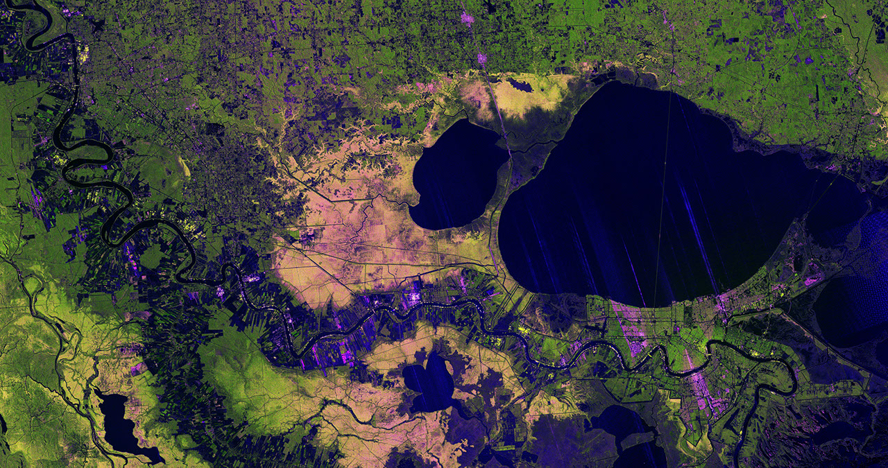
The NISAR (NASA-ISRO Synthetic Aperture Radar) Earth-observing satellite’s L-band synthetic aperture radar (SAR) instrument captured this image of the Mississippi River Delta region in southeastern Louisiana on Nov. 29, 2025.
The colors in the image represent varying types of cover, which tend to reflect microwaves from the radar differently. Portions of New Orleans appear green, a sign that the radar’s signals may be scattering from buildings that are oriented at different angles relative to the satellite’s orbit. Parts of the city appear magenta where streets that run parallel to the satellite’s flight track cause the signals to bounce strongly and brightly off buildings and back to the instrument.
The resolution of the image is fine enough to make clear, right of center, the Lake Pontchartrain Causeway — twin bridges that, at nearly 24 miles (39 kilometers) in length, make up the world’s longest continuous bridge over water.
The bright green areas to the west of the Mississippi River, which snakes from Baton Rouge in the upper left to New Orleans in the lower right, are healthy forests. There, tree canopies and other vegetation are causing NISAR’s microwaves to bounce in numerous directions before returning to the satellite. Meanwhile, the yellow-and-magenta-speckled hues of Maurepas Swamp, directly west of Lake Pontchartrain and the smaller Lake Maurepas, indicate that the tree populations in that wetland forest ecosystem have thinned.
On either bank of the Mississippi, the image shows parcels of varying shapes, sizes, and cover. Darker areas suggest fallow farm plots, while bright magenta indicates that tall plants, such as crops, may be present.
Figure A is a version of the same image with labels, locator inset, scale, or compass.
The L-band system uses a 9-inch (24-centimeter) wavelength that enables its signal to penetrate forest canopies and measure soil moisture as well as motion of ice surfaces and land down to fractions of an inch — the latter information being key to understanding how the land surface moves before, during, and after earthquakes, volcanic eruptions, and landslides.
The S-band radar, provided by the Indian Space Research Organisation’s Space Applications Centre, uses a 4-inch (10-centimeter) microwave signal that’s more sensitive to small vegetation, which makes it effective at monitoring certain types of agriculture and grassland ecosystems.
Launched in July 2025, NISAR is collecting data that will benefit humanity by helping researchers around the world better understand changes in our planet’s surface, including its ice sheets, glaciers, and sea ice. It also will capture changes in forest and wetland ecosystems and track movement and deformation of our planet’s crust by phenomena such as earthquakes, landslides, and volcanic activity. The global and rapid coverage from NISAR will provide unprecedented support for disaster response, producing data to assist in mitigating and assessing damage, with observations before and after catastrophic events available in short time frames.
Find more information about NISAR here: https://science.nasa.gov/mission/nisar/