Is a super El Niño imminent, and what could the impacts be?
A super El Niño led to flooding in China in 1998 ROBYN BECK/AFP via Getty Images In the past
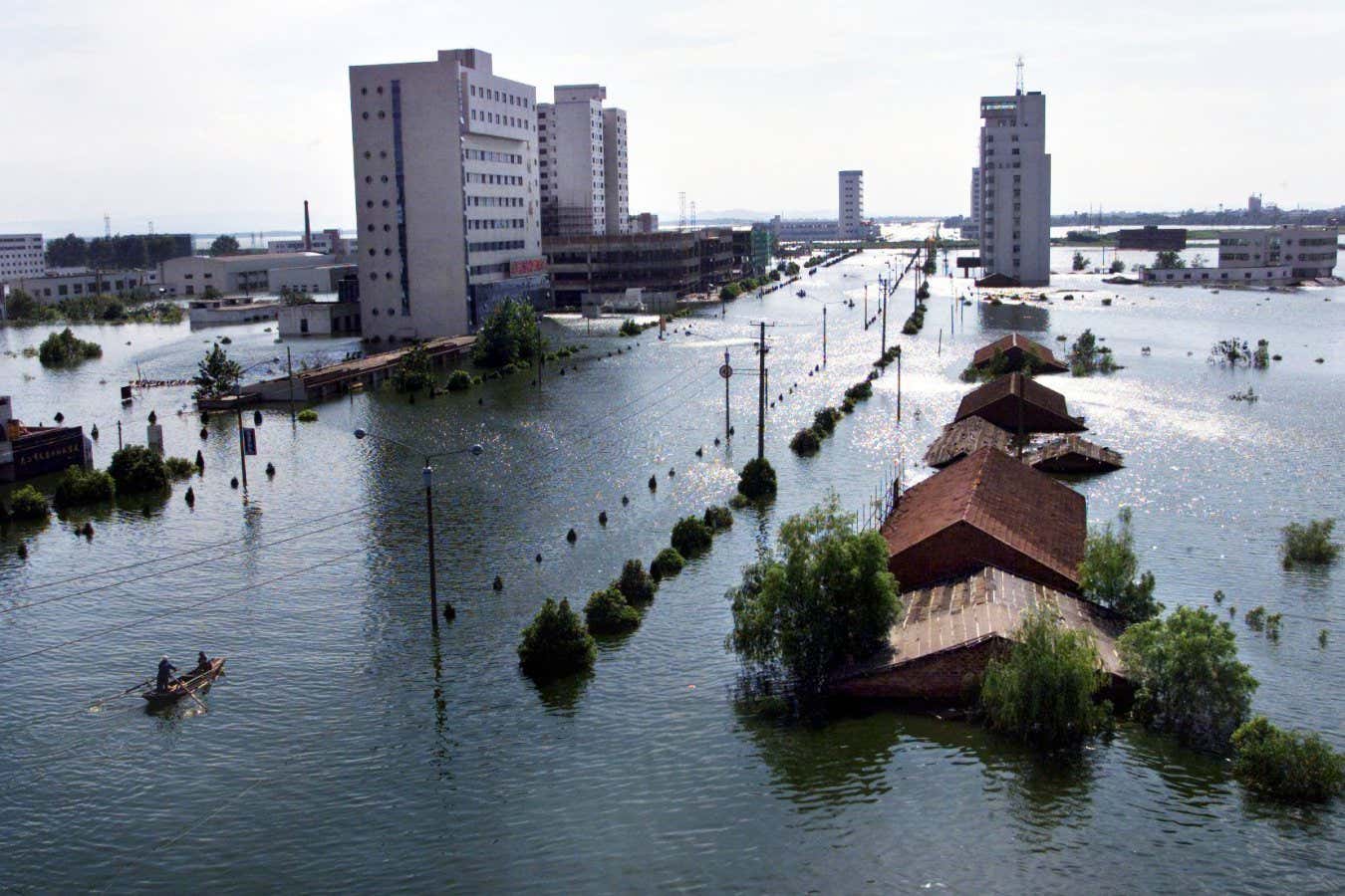
A super El Niño led to flooding in China in 1998
ROBYN BECK/AFP via Getty Images
In the past month, weather models have begun to show that a very strong El Niño climate phase could develop later this year, potentially the strongest we have ever seen.
Many are calling this a “super El Niño” or even a “Godzilla El Niño”. It could bring droughts to some areas of the world, floods to others and set the planet up for the hottest year on record.
“The forecast from now is warming faster in the tropical Pacific than at any other time so far this century,” says Adam Scaife at the Met Office, the UK’s national weather service. “So something unusual is going on.”
What is a Super El Niño?
El Niño is a natural climate pattern that raises temperatures and disrupts weather around the world. It typically happens when the trade winds blowing east to west over the tropical Pacific weaken, reducing the upwelling of deep cold water and allowing warm surface water to slosh back across the central and eastern Pacific. Atmospheric circulation shifts eastward in turn.
The El Niño begins when sea surface temperatures in the central Pacific reach 0.5°C above the long-term average. If they reach 2°C or more above the long-term average, it’s a very strong or “super” El Niño.
Peruvian fishers noticed the warming tends to peak in December, which is why they called it El Niño after the Christ child.
While El Niño happens every few years, super events have only occurred in 1982-83, 1997-98 and 2015-16.
How likely is it to happen?
A burst of westerly winds in March and early April has been blowing massive amounts of warm water towards the central and eastern Pacific, setting the stage for a strong or very strong El Niño. Met Office models project the temperature anomaly there will near 2°C by September, and a group of models run by the European Centre for Medium-Range Weather Forecasts (ECMWF) gives a roughly 50 per cent chance of reaching a 2.5°C anomaly by October.
The US National Weather Service has projected a 25 per cent chance of a super El Niño by the end of the year. If two of the models in the European group that are projecting central Pacific temperature anomalies above 3°C by September turn out to be correct, then this will be the strongest El Niño ever observed.
But the signs of a developing El Niño are still faint at this point, and models struggle to make accurate predictions, a phenomenon known as the “spring predictability barrier”. Meteorologists will have a better idea of the strength of the coming El Niño in May or June.
What are the impacts on weather?
The changes in atmospheric circulation over the central and eastern Pacific spread through long-distance “teleconnections”, altering weather patterns around the world. That can lead to impacts like crop failures, coral bleaching and disease spread and cause billions of pounds in damages.
“Things are perturbed, they’re shifted away from normal,” says Tim Stockdale at the ECMWF. “It’s not necessarily that the storms, let’s say rainfall, is more… It’s just happening in places that don’t normally get it.”
El Niño typically brings more stormy, wet weather to the southern coasts of North and South America, the Horn of Africa and China, raising the risk of flooding.
At the same time, hot, dry weather tends to hit places like Australia and South-East Asia, central and southern Africa, India and the Amazon rainforest, increasing the risk of drought, heatwaves and wildfires.
The effects are more complex in the UK and north-western Europe. There, El Niño can raise the chances of hotter summers and colder winters, but it can also bring wet, mild winters, depending on what other climate patterns do.
Disastrous effects can continue after El Niño has peaked. In the summer following the 1997-98 super El Niño, severe rainfall and flooding in China’s densely populated Yangtze river valley killed 3000 people, destroyed the homes of 15 million and caused $20 billion in economic losses.
The one piece of good news is that fewer hurricanes form off the Caribbean and east coast of the US during El Niño. Amplified atmospheric circulation results in greater wind shear, so these storms tend to blow themselves out quickly, rather than gradually developing into huge hurricanes.
How will it affect the climate?
If climate change is like an incoming tide, gradually raising temperatures, then El Niño is like a giant wave that temporarily boosts them even more. A strong event could increase global temperatures by 0.2°C.
The last time El Niño occurred, in 2024, it brought the hottest year on record, with global temperatures briefly exceeding the Paris Agreement limit of 1.5°C for the first time. If a super El Niño develops, many think 2027 will set a new record.
“Given that we’re already… close to 1.4, it’s quite likely or plausible that 2027 is going to go above the 1.5 threshold,” says Scaife. “It’s a sign that [global warming is] getting very close to the Paris threshold.”
Are we going to see more super El Niño events?
El Niño temperatures in the central Pacific are getting hotter due to climate change, but so is the long-term average of temperatures that they are compared to, so we shouldn’t see an increase in the number or strength of El Niño temperature anomalies under this definition. For this reason, the US National Weather Service has begun classifying El Niño by how much warmer the central Pacific is than other parts of the tropics at present, although this new definition has yet to be picked up elsewhere.
Instances of El Niño and its cooler counterpart La Niña have been more frequent and more extreme over the past 50 to 60 years. One study suggested climate change has amplified these swings between warm and cooler temperatures in the central Pacific by 10 per cent. But given that we only have about 150 years of data, and our early measurements were less reliable, most scientists are still reluctant to say climate change is supercharging El Niño.
“It’s a very tricky question, will El Niño change under climate change,” says Stockdale. “The answer is it probably will.”
What is clear is that global warming is worsening the impacts of El Niño. Elevated global temperatures lead to more evaporation from the soil and more moisture held in the atmosphere, which amplifies extreme weather like droughts and flooding.
“We call it an intensification of the hydrological cycle,” says Stockdale. “Because El Niño can cause significant changes in normal precipitation it can be exacerbated by climate change.”
Topics: