

Extreme January Cold – NASA Science
In the wake of a winter storm that blanketed numerous U.S. states with snow and ice, unusually low temperatures
In the wake of a winter storm that blanketed numerous U.S. states with snow and ice, unusually low temperatures continued to grip a large swath of the nation east of the Rockies in late January 2026. The cold spell was notable for severity, longevity, and geographic scope.
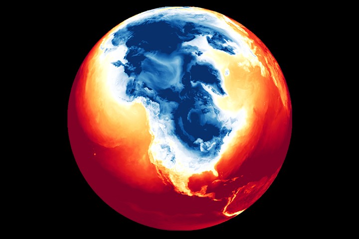
This animation depicts surface air temperatures across part of the Northern Hemisphere, including North America, from January 21 to 29. It combines satellite observations with temperatures calculated by a version of the Goddard Earth Observing System (GEOS) global model, which uses mathematical equations to simulate physical processes in the atmosphere.
Dark blue areas indicate the lowest surface air temperatures. The brief pulses show daily warming and cooling, while the broader pattern reveals cold air spreading south and east and lingering through much of the week.
According to the National Weather Service (NWS), the surge of Arctic air pushed deep into the United States on January 22, ushering in a period of low temperatures and harsh wind chills. The cold coincided with a jet of moisture to produce significant accumulations of snow and ice spanning from the U.S. Southwest to New England.
In the days after the storm, dangerously cold weather persisted. In the Midwest, for example, the temperature in Alliance, Nebraska, dropped to minus 26 degrees Fahrenheit (minus 32 degrees Celsius) on January 24, the lowest daily minimum temperature for that date on record, according to preliminary NWS reports. In the South, an extreme cold warning was in effect in south-central Texas overnight on January 26, with temperatures dipping into the single digits. By January 27, parts of the South had started to see slight warming, but wind chills down to -20°F (-29°C) continued across the Midwest and Northeast.
According to meteorologists, the cold snap was caused by frigid air from the Canadian and Siberian Arctic funneling into eastern North America, then being driven south as high-pressure systems forced the jet stream to dip. Forecasts called for another blast of Arctic air late in the week, with below-normal temperatures persisting into early February.
The lingering cold has posed extra challenges to those who remained without power or heat after the storm and for those working to clean up, clear streets, and restore power and transportation services.
NASA’s Disasters Response Coordination System has been activated to support agencies responding to the winter storm. The team will be posting maps and data products on its open-access mapping portal as new information becomes available.
NASA Earth Observatory images and animation by Lauren Dauphin, using GEOS data from the Global Modeling and Assimilation Office at NASA GSFC. Story by Kathryn Hansen.
- The Conversation (2026, January 24) How the polar vortex and warm ocean intensified a major US winter storm. Accessed January 29, 2026.
- NASA Earth Observatory (2026, January 28) Snow Buries the U.S. Interior and East. Accessed January 29, 2026.
- NBC News (2026, January 27) Millions remain under warnings as extreme cold has icy grip on much of the U.S. Accessed January 29, 2026.
- NWS Weather Prediction Center, via X (2026, January 27) Dangerously cold temperatures continue. Accessed January 29, 2026.
- The Washington Post (2026, January 28) Extreme cold spell shaping up as one of D.C.’s longest in 150 years. Accessed January 29, 2026.
- Yale Climate Connections (2026, January 23) Winter 2025-26 (finally) hits the U.S. with a vengeance. Accessed January 29, 2026.