


Egypt’s Karnak Temple may have risen from water like a creation myth
An international team of researchers led by Uppsala University has completed the most extensive geoarchaeological investigation ever conducted at
An international team of researchers led by Uppsala University has completed the most extensive geoarchaeological investigation ever conducted at Egypt’s Karnak Temple complex. Karnak ranks among the largest temple complexes of the ancient world and forms part of a UNESCO World Heritage site located within the modern city of Luxor.
The findings, published in Antiquity, shed new light on how the temple was founded, how its setting may connect to ancient Egyptian religious beliefs, and how people interacted with the surrounding river landscape over more than 3,000 years of continuous use.
“Our research presents the clearest understanding of the landscape upon which the ancient Egyptians founded their temple at Karnak approximately 4000 years ago,” says Dr. Angus Graham, Uppsala University, who led the team.
From Flooded Terrain to Sacred Ground
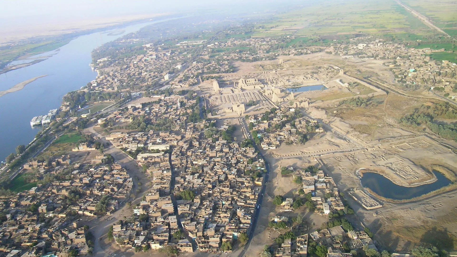
Today, Karnak Temple sits about 500 meters east of the Nile near Luxor, once the religious capital of ancient Egypt known as Thebes. Thousands of years ago, however, the environment around the site looked very different.
To reconstruct that earlier landscape, the research team examined 61 sediment cores taken from inside and around the temple grounds and analyzed tens of thousands of ceramic fragments. These materials allowed the researchers to track changes in waterways and land surfaces over long periods of time.
The results show that before roughly 2520 BCE, the area would have been unsuitable for permanent settlement. Fast-moving Nile floodwaters regularly covered the site, making long-term occupation impossible. The earliest likely human activity at Karnak dates to the Old Kingdom (c.2591-2152 BCE). Pottery fragments support this timeline, with the oldest pieces dating to between c.2305 to 1980 BCE.
The land that eventually supported Karnak formed when Nile river channels carved paths on both the western and eastern sides of a natural terrace. This process created a rare island of higher ground in what is now the east/south-east section of the temple precinct. That elevated land provided a stable base for early settlement and the first stages of temple construction.
Shifting River Channels and Temple Expansion
As centuries passed, the river channels on either side of the site gradually moved. This shift opened up additional space, allowing Karnak to expand into the massive complex seen today.
One of the study’s most unexpected findings involved the eastern river channel. Researchers discovered that it was far more clearly defined and possibly larger than the western channel, which had received most of the attention in earlier archaeological work.
“What also surprised us was the longevity of this eastern channel. It remains a very minor channel until the arrival of the Romans in the first century BCE. We also have evidence of how the Ancient Egyptians engineered the landscape. They may well have been impatient to expand their temple footprint as they dumped desert sands into a minor river channel that was already starting to silt up,” adds Angus Graham.
Landscape Tied to Ancient Creation Beliefs
The reconstructed landscape closely matches descriptions found in ancient Egyptian creation myths. This resemblance suggests that religious ideas may have influenced the choice of Karnak’s location.
Texts from the Old Kingdom describe the creator god appearing as a mound of high ground emerging from surrounding waters referred to as ‘the lake’. The island identified beneath Karnak is the only known example of such high ground encircled by water in the region.
“It’s tempting to suggest the Theban elites chose Karnak’s location for the dwelling place of a new form of the creator god, ‘Ra-Amun’, as it fitted the cosmogonical scene of high ground emerging from surrounding water,” says Dr. Ben Pennington, lead author of the paper and a Visiting Fellow in Geoarchaeology at the University of Southampton.
Later writings from the Middle Kingdom (c.1980-1760 BC) expand on this theme, describing the ‘primeval mound’ rising from the ‘Waters of Chaos’. During this time, the annual retreat of the Nile floodwaters would have visually echoed these beliefs, as the elevated ground beneath Karnak appeared to rise and grow as the waters receded.
Broader Climate Context
The new study builds on earlier work published in Nature Geoscience in 2024 (doi.org/10.1038/s41561-024-01451-z). That research documented how shifts in climate and environment have shaped the Egyptian Nile Valley over the past 11,500 years.
This latest work was conducted under the auspices of the Egypt Exploration Society (London) and carried out with a permit from the Ministry of Tourism and Antiquities (Egypt).