An Unrelenting Tule Fog – NASA Science
An atmospheric phenomenon occurring over much of California was unmistakable in satellite imagery in late autumn 2025. Fog stretching
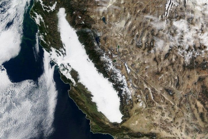
An atmospheric phenomenon occurring over much of California was unmistakable in satellite imagery in late autumn 2025. Fog stretching some 400 miles (640 kilometers) across the state’s Central Valley appeared day after day for more than two weeks in late November and early December. Known as tule (TOO-lee) fog, named after a sedge that grows in the area’s marshes, these low clouds tend to form in the valley in colder months when winds are light and soils are moist.
This animation shows a sprawling blanket of white fog filling most or all of the valley from Redding to Bakersfield between November 24 and December 9, 2025. While the fog mostly remained hemmed in by the Coastal Range and the Sierra Nevada, it sometimes spilled through the Carquinez Strait toward San Francisco Bay. These images were acquired with the MODIS (Moderate Resolution Imaging Spectroradiometer) instrument on NASA’s Terra satellite and the VIIRS (Visible Infrared Imaging Radiometer Suite) on the NOAA-20 and Suomi NPP satellites.
The Central Valley is fertile ground for the formation of tule fog, a persistent radiation fog, in late autumn and winter. It occurs when air near the surface, laden with moisture from evaporation, cools and the water saturates the air. If winds are calm, water droplets accumulate into fog clouds near the ground.
Plenty of water was present in the valley’s soils following a very wet autumn. Across nearly all of central and southern California, precipitation totals from September through November 2025 were among the top 10 percent on record, California Institute for Water Resources climate scientist Daniel Swain noted on his Weather West blog. In late November, a very stable high-pressure system developed over the state, which acted like a lid that trapped moist air and confined the fog layer to the valley. With no major storms moving through to disrupt the stratification, the tule fog endured.
Temperatures have been notably cooler in the valley under the fog layer, in sharp contrast to the rest of the state, which was mostly warmer than normal. Despite the contrast, however, the ambient air mass has been warmer overall, Swain wrote. This may be due in part to warm ocean water offshore and a low Sierra Nevada snowpack sending less cold air downslope, he added.
The warmer overall temperatures could explain why fog has lingered at a slightly higher level—more like stratus clouds—at certain times and locations, said Swain. Colder temperatures would be necessary to produce the densest fog near the surface. The somewhat higher cloud in 2025 has differed from past events, when low visibility at ground level has caused major traffic incidents.
Central California has seen long stretches of cold, socked-in days in the past. In 1985, for example, Fresno experienced 16 consecutive days of dense fog, and Sacramento endured 17, according to news reports. Researchers have found, however, that tule fog has been forming less often in California in recent decades. Foggy days are beneficial for the valley’s fruit and nut trees, which need sufficient rest between growing seasons to be most productive. The fog typically comes with chilly weather that brings on a dormant period; it also shields trees from direct sunlight that would otherwise warm the plant buds.
NASA Earth Observatory images by Lauren Dauphin, using MODIS data from NASA EOSDIS LANCE and GIBS/Worldview, and VIIRS data from NASA EOSDIS LANCE, GIBS/Worldview, the Suomi National Polar-orbiting Partnership, and the Joint Polar Satellite System (JPSS). Story by Lindsey Doermann.
- Baldocchi, D., and Waller, E. (2014) Winter fog is decreasing in the fruit growing region of the Central Valley of California. Geophysical Research Letters, 41, 3251–3256.
- NASA Earth Observatory (2020, December 22) Cool Yule Tule. Accessed December 10, 2025.
- National Weather Service Radiation Fog. Accessed December 10, 2025.
- The Washington Post (2025, November 29) Why a 400-mile long fog bank lingered over California for a week. Accessed December 10, 2025.
- Weather West (2025, December 6) Under a resilient ridge, prolonged tule fog episode brings cold and damp weather to the Central Valley but anomalously warm/dry weather elsewhere. Accessed December 10, 2025.
- Weather West, via YouTube (2025, December 2) California weather update: Tule fog, a December dry spell, and an overview of our topsy-turvy autumn. Accessed December 10, 2025.