

Contours of the James Bay Lowlands
Early spring around Hudson Bay in northern Canada is largely indistinguishable from winter. Sea ice still clings to land,
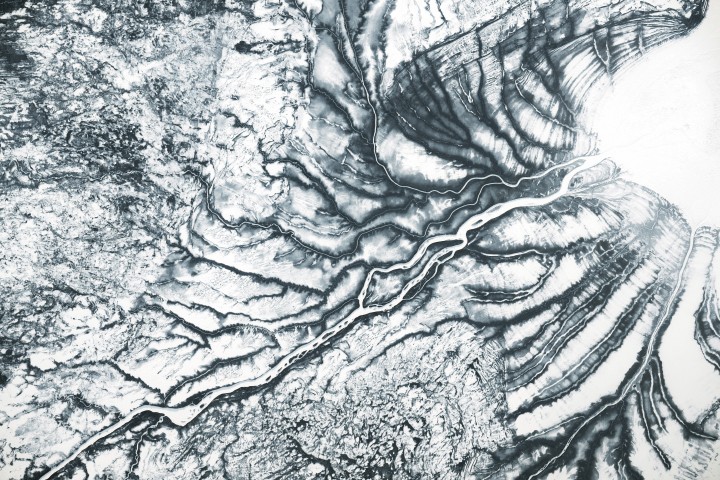
Early spring around Hudson Bay in northern Canada is largely indistinguishable from winter. Sea ice still clings to land, and the boggy lowlands remain frozen. In the dulled tones of the boreal landscape, however, snow helps accentuate the area’s subtle topography. In late March 2026, an astronaut aboard the International Space Station captured this photo of frozen channels feeding Hannah Bay—a southern offshoot of James Bay, which is itself an extension of Hudson Bay.
Some of the patterns visible in the photo relate to the region’s ice age history. During the Pleistocene Epoch, the Laurentide Ice Sheet covered most of present-day Canada. It centered on Hudson Bay, where its immense weight depressed the land. Since the Last Glacial Maximum about 20,000 years ago, the ice has retreated and the land has been bouncing back. Glacial isostatic adjustment, or isostatic rebound, is relatively rapid around southern Hudson Bay; the surface continues to rise about 10 millimeters (0.4 inches) per year, or 1 meter per century.
The process has left a fingerprint on the newly emerged land. In this photo, faint, closely spaced ridges parallel the shore of ice-covered James Bay at the terminus of the Harricana river. These beach ridges formed from tidal action reworking sands and silts along the shore, with newer ridges developing along the water as land rises and relative sea level drops.
The Harricana and adjacent waterways flow through boreal peat bogs, or muskeg, in the Hudson Bay Lowlands on their journey out to sea. As the world’s second largest peatland complex, the lowlands store significant amounts of soil carbon. Elsewhere around the bay, the landscape retains features carved by glaciers, such as drumlins and eskers.
With the approach of summer, the muted colors of the frozen months give way to a more varied palette. Peatlands take on a lush, green appearance, and partially decayed organic matter in the peat releases tannins that stain the water dark brown like a strong tea. Sea ice that has remained attached to the James Bay shoreline for several months typically begins to break up in mid- to late-May, with melting complete by the end of July.
Astronaut photograph ISS074-E-417241 was acquired on March 26, 2026, with a Nikon Z9 digital camera using a focal length of 200 millimeters. It was provided by the ISS Crew Earth Observations Facility and the Earth Science and Remote Sensing Unit at NASA Johnson Space Center. The image was taken by a member of the Expedition 74 crew. The image has been cropped and enhanced to improve contrast, and lens artifacts have been removed. The International Space Station Program supports the laboratory as part of the ISS National Lab to help astronauts take pictures of Earth that will be of the greatest value to scientists and the public, and to make those images freely available on the Internet. Additional images taken by astronauts and cosmonauts can be viewed at the NASA/JSC Gateway to Astronaut Photography of Earth. Story by Lindsey Doermann.
- EBSCO Research Starters (2024) Hudson Bay. Accessed April 14, 2026.
- GRACE Tellus, Glacial Isostatic Adjustment (GIA). Accessed April 14, 2026.
- NASA Earth Observatory (2023, June 17) James Bay Melts Out. Accessed April 14, 2026.
- NASA Earth Observatory (2016, October 1) Some Tea With Your River? Accessed April 14, 2026.
- Price, J.S., et al. (1988) Vegetation patterns in James Bay coastal marshes. II. Effects of hydrology on salinity and vegetation. Canadian Journal of Botany, 66(12): 2586-2594.
- Rice, J.M., et al. (2024) The surficial geology record of ice stream catchment dynamics and ice-divide migration in the Quebec-Labrador sector of the Laurentide Ice Sheet. Quaternary Science Advances, 13, 100123.