Massive magma surge sparked 28,000 Santorini earthquakes
[ad_1] At the start of 2025, Santorini and nearby parts of the Aegean Sea were rattled by tens of
[ad_1]
At the start of 2025, Santorini and nearby parts of the Aegean Sea were rattled by tens of thousands of earthquakes. Scientists have now determined what caused the intense shaking. In a study published in Nature, researchers from GFZ Helmholtz Centre for Geosciences and GEOMAR Helmholtz Centre for Ocean Research Kiel, working with international partners, present a detailed geological investigation of the seismic crisis.
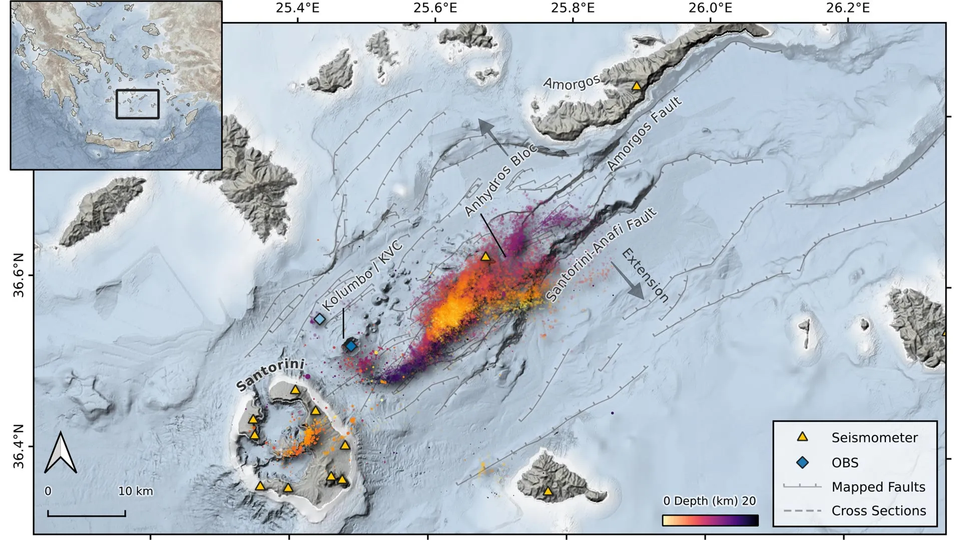
By combining data from land based seismic stations and ocean floor instruments installed at the underwater volcano Kolumbo, located 7 km from Santorini, the team reconstructed what was happening deep below the surface. They also applied a newly developed artificial intelligence method to pinpoint earthquake locations with far greater precision. Their analysis shows that roughly 300 million cubic meters of magma rose from deep within the crust and stalled about four kilometers beneath the seafloor. As this molten rock pushed upward, it fractured surrounding rock layers, triggering thousands of earthquakes and tremors.
Santorini’s Volcanic and Tectonic Setting
Santorini sits in the eastern Mediterranean within the Hellenic volcanic arc, one of Europe’s most geologically active regions. The islands form the rim of a caldera created by a massive eruption around 3,600 years ago.
Close by lies the active submarine volcano Kolumbo. The broader region is crisscrossed by active fault lines created as the African Plate presses northeastward against the Hellenic Plate. The Mediterranean crust here is broken into smaller microplates that shift, sink, and partially melt, fueling both earthquakes and volcanic eruptions.
Santorini has erupted multiple times in recorded history, most recently in 1950. In 1956, two powerful earthquakes struck the southern Aegean Sea between Santorini and the nearby island of Amorgos, only 13 minutes apart. With magnitudes of 7.4 and 7.2, the quakes generated a tsunami.
The earthquake swarm that began in late January 2025 occurred in this same tectonically active zone. Over the course of the crisis, more than 28,000 earthquakes were recorded. The strongest exceeded magnitude 5.0. Because it was initially unclear whether the shaking was caused by shifting faults or volcanic activity, residents were understandably alarmed.
Magma Movement Behind the Earthquake Swarm
The new findings point to magma rising from depth as the driving force behind the swarm. The process actually began months earlier. In July 2024, magma started accumulating in a shallow reservoir beneath Santorini, causing the island to lift slightly by a few centimeters.
Seismic activity increased in early January 2025. By late January, magma began rising again from deeper levels, accompanied by intense earthquake activity. The cluster of quakes gradually migrated more than 10 kilometers northeast of Santorini. During this phase, earthquake depths shifted upward in pulses, moving from about 18 kilometers below the surface to just 3 kilometers beneath the seafloor.
Researchers combined detailed earthquake mapping with satellite radar measurements (InSAR), GPS stations, and seafloor sensors to model the sequence of events.
Dr. Marius Isken, a geophysicist at GFZ and one of the two lead authors, explains: “The seismic activity was typical of magma ascending through the Earth’s crust. The migrating magma breaks the rock and forms pathways, which causes intense earthquake activity. Our analysis enabled us to trace the path and dynamics of the magma ascent with a high degree of accuracy.”
As the magma shifted, Santorini gradually sank back down. The scientists interpret this subsidence as evidence of a previously unknown hydraulic connection between Santorini and the nearby Kolumbo volcano.
Dr. Jens Karstens, a marine geophysicist at GEOMAR and co lead author, says: “Through close international cooperation and the combination of various geophysical methods, we were able to follow the development of the seismic crisis in near real time and even learn something about the interaction between the two volcanoes. This will help us to improve the monitoring of both volcanoes in the future.”
AI and Seafloor Sensors Reveal Hidden Activity
Two main factors allowed researchers to map the underground processes in exceptional detail. First, scientists at GFZ used an AI driven system capable of automatically analyzing vast amounts of seismic data. Second, as part of the MULTI-MAREX project, GEOMAR had already deployed underwater instruments at the crater of Kolumbo in early January.
These seafloor sensors recorded not only earthquake signals but also pressure changes caused by the seabed sinking as much as 30 centimeters during magma intrusion beneath Kolumbo.
Even though seismic activity has declined, monitoring efforts continue. GFZ scientists are conducting repeated measurements of volcanic gases and temperatures on Santorini, while GEOMAR currently operates eight seafloor monitoring platforms in the region.
Prof. Dr. Heidrun Kopp, Professor of Marine Geodesy at GEOMAR and project manager of MULTI-MAREX, says: “The joint findings were always shared with the Greek authorities in order to enable the fastest and most accurate assessment of the situation possible in the event of new earthquakes.” Co author Prof. Dr. Paraskevi Nomikou of the University of Athens adds: “This long-standing cooperation made it possible to jointly manage the events at the beginning of the year and to analyse them so precisely from a scientific point of view. Understanding the dynamics in this geologically highly active region as accurately as possible is crucial for the safety and protection of the population.”
About MULTI-MAREX
MULTI-MAREX is one of four projects within the research mission ‘Paths to improved risk management in the area of marine extreme events and natural hazards’ (mareXtreme), led by the German Marine Research Alliance (DAM). The initiative brings together ten partner institutions from six universities along with the Helmholtz Centres GFZ and GEOMAR. Its goal is to create a real world research laboratory to better understand marine hazards such as earthquakes, volcanic eruptions, and tsunamis in the central Mediterranean.
[ad_2]
Source link